Amazon River Trip
October 1986
Dear Cha-Wel-Dor-Sue:
![]() This
Dad-O-GRAM will endeavor to tell you something of our trip on the
Society Expedition's Ship, V Society Explorer, down the Amazon River
from Iquitos, Peru, to Manaus, Brazil, the capital of the State of
Amazonia. Immediately, I must confess that it is difficult to
describe Amazonia, for it must be seen, experienced, and felt before
its immensity in size, and its enormous variety of plant and animal
life, in its rivers and rain forests, can be appreciated. Reading
will acquaint you with the facts about the greatest river in the
world, but it must be seen first-hand in its virtually virgin state
(Upper Amazon) before you can truly appreciate this amazing river. It
is ever changing in shape and design, and changes each year with each
flood season, during which time, the river may rise and fall as much
as 40 feet, depending upon the rain fall in the Andes and over the
over 1,000 tributaries that flow into it. Last year's navigational
charts are useless, as I learned from the Captain on the bridge of
our ship. The Amazon is the very antithesis of the Rhine and the
Danube, that are beautifully marked with buoys, distance markers, and
directional signals. Yes, the Amazon is unique, and Pat and I are
glad we had this unusual experience, but I doubt we would ever repeat
the performance. It is most rewarding but also very
rugged.
This
Dad-O-GRAM will endeavor to tell you something of our trip on the
Society Expedition's Ship, V Society Explorer, down the Amazon River
from Iquitos, Peru, to Manaus, Brazil, the capital of the State of
Amazonia. Immediately, I must confess that it is difficult to
describe Amazonia, for it must be seen, experienced, and felt before
its immensity in size, and its enormous variety of plant and animal
life, in its rivers and rain forests, can be appreciated. Reading
will acquaint you with the facts about the greatest river in the
world, but it must be seen first-hand in its virtually virgin state
(Upper Amazon) before you can truly appreciate this amazing river. It
is ever changing in shape and design, and changes each year with each
flood season, during which time, the river may rise and fall as much
as 40 feet, depending upon the rain fall in the Andes and over the
over 1,000 tributaries that flow into it. Last year's navigational
charts are useless, as I learned from the Captain on the bridge of
our ship. The Amazon is the very antithesis of the Rhine and the
Danube, that are beautifully marked with buoys, distance markers, and
directional signals. Yes, the Amazon is unique, and Pat and I are
glad we had this unusual experience, but I doubt we would ever repeat
the performance. It is most rewarding but also very
rugged.
![]() Most
of our companions on the trip were people essentially interested in
natural history and the natural sciences, and approximately one-third
were from the New York Botanical Society and approximately one-third
from the Missouri Botanical Society; the rest of us were interested
primarily in seeing the Amazon River itself in all its variety. Among
some of my friends were the bird-watchers who wanted to add to their
score of birds seen, and others who were fishermen who wanted to see
and catch a variety of fish unlike anything seen in their countries.
Our passenger list included people from England, Canada, and
Switzerland, and our distinguished lecture team included four men and
one woman, all of whom held Doctorates, and who were engaged in
research work in the Amazon Basin. They included an ethno-botanist, a
forest biologist, an ornithologist, an ecologist, and a
geomorphologist of the Amazon River, and even an orchid specialist
whose research station was in Kite, Ecuador. All were knowledgeable,
interesting, and all presented fascinating lectures with slides and
each headed up field trips to various areas and sites along the river
and its tributaries.
Most
of our companions on the trip were people essentially interested in
natural history and the natural sciences, and approximately one-third
were from the New York Botanical Society and approximately one-third
from the Missouri Botanical Society; the rest of us were interested
primarily in seeing the Amazon River itself in all its variety. Among
some of my friends were the bird-watchers who wanted to add to their
score of birds seen, and others who were fishermen who wanted to see
and catch a variety of fish unlike anything seen in their countries.
Our passenger list included people from England, Canada, and
Switzerland, and our distinguished lecture team included four men and
one woman, all of whom held Doctorates, and who were engaged in
research work in the Amazon Basin. They included an ethno-botanist, a
forest biologist, an ornithologist, an ecologist, and a
geomorphologist of the Amazon River, and even an orchid specialist
whose research station was in Kite, Ecuador. All were knowledgeable,
interesting, and all presented fascinating lectures with slides and
each headed up field trips to various areas and sites along the river
and its tributaries.
![]() Before
I discuss the river itself, perhaps a word or two about its history
may be of interest. In 1500, the Spanish sea captain, Vesinte Yaniz
Pinzon, while exploring the East Coast of South America, found
himself in a patch of fresh water 120 miles out to sea and named it
La Mer Dulce', or the Fresh Water Sea.
Before
I discuss the river itself, perhaps a word or two about its history
may be of interest. In 1500, the Spanish sea captain, Vesinte Yaniz
Pinzon, while exploring the East Coast of South America, found
himself in a patch of fresh water 120 miles out to sea and named it
La Mer Dulce', or the Fresh Water Sea.
![]() In
investigating this phenomena, he found that its origin was a river
some 40 miles wide, which, as he traveled upstream, had islands
"larger than Switzerland''. He was actually at that time at the very
mouth of the Amazon River as it emptied into the Atlantic Ocean, and
while moving upstream, began to see manifestations of its enormous
delta.
In
investigating this phenomena, he found that its origin was a river
some 40 miles wide, which, as he traveled upstream, had islands
"larger than Switzerland''. He was actually at that time at the very
mouth of the Amazon River as it emptied into the Atlantic Ocean, and
while moving upstream, began to see manifestations of its enormous
delta.
![]() The
real glory of discovering the Amazon River, better known in those
days as the Solimoens, goes to the Spanish explorer Francisco de
0rellana, a companion of Pizarro, during the conquest of Peru. He
crossed the Andes and penetrated into the forest on the eastern side
of the mountains until he finally reached the Coca River, a tributary
of the Upper Amazon. There, he built a small fleet of ships and
sailed down the river, fully intending to return upstream and report
his findings to Pizarro. However, the current proved too strong and
he had to continue downstream, a distance of over 2,135 miles, until
he reached the Atlantic Ocean. His chronicler, Friar Carvajal,
originated the name Amazon when he reported attacks by women warriors
like the Amazons of Greek myth.
The
real glory of discovering the Amazon River, better known in those
days as the Solimoens, goes to the Spanish explorer Francisco de
0rellana, a companion of Pizarro, during the conquest of Peru. He
crossed the Andes and penetrated into the forest on the eastern side
of the mountains until he finally reached the Coca River, a tributary
of the Upper Amazon. There, he built a small fleet of ships and
sailed down the river, fully intending to return upstream and report
his findings to Pizarro. However, the current proved too strong and
he had to continue downstream, a distance of over 2,135 miles, until
he reached the Atlantic Ocean. His chronicler, Friar Carvajal,
originated the name Amazon when he reported attacks by women warriors
like the Amazons of Greek myth.
![]() A
few facts, largely statistical, may be of added interest. For years,
the Nile was considered the longest river in the world (4,000 miles)
but recently, a couple traced the Amazon to its origin on Mount
Huarga in Peru, and found that the Amazon was indeed as long as the
Nile. At this point, all comparisons cease. The flow of the Amazon
exceeds the combined flow of the next eight largest rivers on earth
and while it rivals the Nile in length, it is 60 times greater in its
discharge at its mouth. At maximum flood, it pours eight trillion
gallons into the ocean every day, enough to furnish 200 times the
municipal water requirements of the United States, or 20 times its
total industrial, farming and power needs. The Nile has no
tributaries in its final l,500 miles, whereas the Amazon gathers
water from over 1,100 tributaries, some larger than the Mississippi
River. The average flow is 120,000 cubic meters a second, which
means, for example, it could increase the water level of Lake Geneva,
Switzerland, 3.3 feet in 81 minutes! Another comparison is that it
delivers as much water in one day as the Thames does in a whole year.
In fact, as noted by the Spanish explorer, the torrent of water at
its mouth draws back the salt water of the Atlantic Ocean for over
100 miles!
A
few facts, largely statistical, may be of added interest. For years,
the Nile was considered the longest river in the world (4,000 miles)
but recently, a couple traced the Amazon to its origin on Mount
Huarga in Peru, and found that the Amazon was indeed as long as the
Nile. At this point, all comparisons cease. The flow of the Amazon
exceeds the combined flow of the next eight largest rivers on earth
and while it rivals the Nile in length, it is 60 times greater in its
discharge at its mouth. At maximum flood, it pours eight trillion
gallons into the ocean every day, enough to furnish 200 times the
municipal water requirements of the United States, or 20 times its
total industrial, farming and power needs. The Nile has no
tributaries in its final l,500 miles, whereas the Amazon gathers
water from over 1,100 tributaries, some larger than the Mississippi
River. The average flow is 120,000 cubic meters a second, which
means, for example, it could increase the water level of Lake Geneva,
Switzerland, 3.3 feet in 81 minutes! Another comparison is that it
delivers as much water in one day as the Thames does in a whole year.
In fact, as noted by the Spanish explorer, the torrent of water at
its mouth draws back the salt water of the Atlantic Ocean for over
100 miles!
![]() It
is also of interest that some 14,000 miles of the Amazon and its
tributaries are navigable, indicating its future potential for
economic development and exploration. At the present moment, most
travel is river travel but a series of trans-Amazonian highways are
being built by the Brazilian government and these will crisscross
this vast area of rain forest, with all of its future ecological
complications.
It
is also of interest that some 14,000 miles of the Amazon and its
tributaries are navigable, indicating its future potential for
economic development and exploration. At the present moment, most
travel is river travel but a series of trans-Amazonian highways are
being built by the Brazilian government and these will crisscross
this vast area of rain forest, with all of its future ecological
complications.
![]() Another
interesting fact is that the nature of the water in the Amazon and
its tributaries is different and three varieties are described: A)
"White water" which is essentially brown and consists of silt flowing
down from the Andes Mountains in Peru, Ecuador and Colombia. B)
"Black Water" contributed largely by the River Negro, which consists
largely of decaying vegetative matter and which is highly acidic and
poor for irrigation. C) "Clear Water" which flows upwards, largely
from tributaries from the south, namely the River Tapajos. Both the
"Black Water" and "Clear Water" contains very little nutrient
material and comos from granite areas where time has leeched and
washed away all the softened surface materials. It is really the silt
from the west that has made the flood plains (shorelines) of the
Amazon so fertile. Yet, a paradox exists here in that the rain
forest, which looks so fertile, is indeed far from fertile and has
accounted largely for the failure of Ludwig's Jarri Project. It was
surprising for me to learn that in the Amazon forest, the soils are
leeched of most minerals, bacteria, and other organisms. Anything
that is broken down is carried away by the frequent rains and river
floods. There is thus no rich soil, few bacteria, and literally no
minerals. The trees survive largely due to the mass of fungi that
coat the trees and whose rootlets called mycorrhiza transfer
nutrients from decaying matter. Insects, particularly ants and
termites, eat the leaves and their exereta forms molds which provide
organic nutrient matter.
Another
interesting fact is that the nature of the water in the Amazon and
its tributaries is different and three varieties are described: A)
"White water" which is essentially brown and consists of silt flowing
down from the Andes Mountains in Peru, Ecuador and Colombia. B)
"Black Water" contributed largely by the River Negro, which consists
largely of decaying vegetative matter and which is highly acidic and
poor for irrigation. C) "Clear Water" which flows upwards, largely
from tributaries from the south, namely the River Tapajos. Both the
"Black Water" and "Clear Water" contains very little nutrient
material and comos from granite areas where time has leeched and
washed away all the softened surface materials. It is really the silt
from the west that has made the flood plains (shorelines) of the
Amazon so fertile. Yet, a paradox exists here in that the rain
forest, which looks so fertile, is indeed far from fertile and has
accounted largely for the failure of Ludwig's Jarri Project. It was
surprising for me to learn that in the Amazon forest, the soils are
leeched of most minerals, bacteria, and other organisms. Anything
that is broken down is carried away by the frequent rains and river
floods. There is thus no rich soil, few bacteria, and literally no
minerals. The trees survive largely due to the mass of fungi that
coat the trees and whose rootlets called mycorrhiza transfer
nutrients from decaying matter. Insects, particularly ants and
termites, eat the leaves and their exereta forms molds which provide
organic nutrient matter.
![]() Orchids
and Bromelids are seen frequently, though not as commonly as in the
higher elevations. They are epiphytes or air-breathing plants and are
not saprophytic, which exist in symbiosis with each other. I was
surprised to learn that orchids are the largest group of flowering
plants in the world and that there are over 30,000 known species.
(Only 212 exist in North America.) Thus, they constitute 10% of all
the flowering plants in the world. Cal Dodson made the history of the
orchid family fascinating. As a urologist, I used the word orchid
frequently to represent the testicle, but little did I realize that
the male gonad was used to describe the name of these beautiful
flowers.
Orchids
and Bromelids are seen frequently, though not as commonly as in the
higher elevations. They are epiphytes or air-breathing plants and are
not saprophytic, which exist in symbiosis with each other. I was
surprised to learn that orchids are the largest group of flowering
plants in the world and that there are over 30,000 known species.
(Only 212 exist in North America.) Thus, they constitute 10% of all
the flowering plants in the world. Cal Dodson made the history of the
orchid family fascinating. As a urologist, I used the word orchid
frequently to represent the testicle, but little did I realize that
the male gonad was used to describe the name of these beautiful
flowers.
![]() As
one views the rain forest from above, it appears to be a dense
luxuriant jungle, but upon examination, it reveals itself to be
otherwise. As one walks through the forest, ever on the lookout for
boa constrictors, anacondas, jungle cats, alligators, and insects
galore, one realizes that the forest is indeed a four or five story
affair. The highest trees tower above all and rise some 135 feet in
the air. Below this, there is a canopy or mantle of trees that rise
somewhere between 40 to 60 feet in the air, and below this, another
grouping of smaller trees some 15 to 20 feet in the air, all resting
on a ground cover of shrubs, bushes, grasses, etc. At this level, it
is dark and only 3 to 4% of the sunlight ever reaches this area.
Hence, there is very little growth and the so-called humus soil is
virtually non-existent. We were told that the plants recycle
themselves. As plants die and decay, their substance is utilized by
the living trees but unfortunately, no base of humus is ever created.
Therefore, if agriculture on a large scale is to be contemplated,
untold tons of fertilizer would be required!
As
one views the rain forest from above, it appears to be a dense
luxuriant jungle, but upon examination, it reveals itself to be
otherwise. As one walks through the forest, ever on the lookout for
boa constrictors, anacondas, jungle cats, alligators, and insects
galore, one realizes that the forest is indeed a four or five story
affair. The highest trees tower above all and rise some 135 feet in
the air. Below this, there is a canopy or mantle of trees that rise
somewhere between 40 to 60 feet in the air, and below this, another
grouping of smaller trees some 15 to 20 feet in the air, all resting
on a ground cover of shrubs, bushes, grasses, etc. At this level, it
is dark and only 3 to 4% of the sunlight ever reaches this area.
Hence, there is very little growth and the so-called humus soil is
virtually non-existent. We were told that the plants recycle
themselves. As plants die and decay, their substance is utilized by
the living trees but unfortunately, no base of humus is ever created.
Therefore, if agriculture on a large scale is to be contemplated,
untold tons of fertilizer would be required!
![]() To
summarize, Amazonia consists mainly of forest and forms more than 56%
of Brazil's national area, but contains only 7% of its population.
Most of the inhabitants live in and around a few cities like Manaus,
Santarem, and Belem, and there are about 150 Indian villages
scattered along the tributaries. There were far more numerous tribes
previously, but many were decimated by diseases introduced by foreign
invasion and especially during the slavery practices which were
introduced during the Rubber Boom (1890-1915).
To
summarize, Amazonia consists mainly of forest and forms more than 56%
of Brazil's national area, but contains only 7% of its population.
Most of the inhabitants live in and around a few cities like Manaus,
Santarem, and Belem, and there are about 150 Indian villages
scattered along the tributaries. There were far more numerous tribes
previously, but many were decimated by diseases introduced by foreign
invasion and especially during the slavery practices which were
introduced during the Rubber Boom (1890-1915).
![]() The
Amazon is virtually on the equator so there is no difference in the
seasons as we understand them. There is, however, a "winter", when it
is completely cool and rainy, and a "summer", when it is warm and
dry. The temperature averages 81° Fahrenheit and hovers between
70° and 90° Fahrenheit all year. Furthermore, it is said it
is always raining somewhere along the river all year, and this I can
believe from our numerous wet experiences.
The
Amazon is virtually on the equator so there is no difference in the
seasons as we understand them. There is, however, a "winter", when it
is completely cool and rainy, and a "summer", when it is warm and
dry. The temperature averages 81° Fahrenheit and hovers between
70° and 90° Fahrenheit all year. Furthermore, it is said it
is always raining somewhere along the river all year, and this I can
believe from our numerous wet experiences.
![]() It
is said that while the temperate areas of the world suffered through
the Glacial Period and all our forests were destroyed (11,000 years
ago), the Amazon remained unchanged and undisturbed and thus has been
in that state for over 100 million years. It thus affords an
opportunity for one to look back into the past. Apparently, the
tropical heat protected this area from the grinding embrace of the
Ice Age.
It
is said that while the temperate areas of the world suffered through
the Glacial Period and all our forests were destroyed (11,000 years
ago), the Amazon remained unchanged and undisturbed and thus has been
in that state for over 100 million years. It thus affords an
opportunity for one to look back into the past. Apparently, the
tropical heat protected this area from the grinding embrace of the
Ice Age.
![]() The
Amazon River is also of unusual interest in that it was here that
Alfred Russell Wallace did his plant and animal research which led
him to his conclusion that species evolved gradually over a period of
time (evolution), rather than being created in their present form
(creationism). Darwin had come to the same conclusion as a result of
his studies. Both of these men were friends and members of the Royal
Geographic Society of England and each presented their findings at
the same time to the Society and both are equally deserving of the
honor of being the Father of the Theory of Evolution, although Darwin
is better known because of his more extensive publications. Other
names, equally renown, such as the French scientist Charles M.
LaCondamine, the German scientist Baron VonHumbolt, and the English
scientists Henry Bates and Richard Russell, all did much of their
research on this amazing Amazon River.
The
Amazon River is also of unusual interest in that it was here that
Alfred Russell Wallace did his plant and animal research which led
him to his conclusion that species evolved gradually over a period of
time (evolution), rather than being created in their present form
(creationism). Darwin had come to the same conclusion as a result of
his studies. Both of these men were friends and members of the Royal
Geographic Society of England and each presented their findings at
the same time to the Society and both are equally deserving of the
honor of being the Father of the Theory of Evolution, although Darwin
is better known because of his more extensive publications. Other
names, equally renown, such as the French scientist Charles M.
LaCondamine, the German scientist Baron VonHumbolt, and the English
scientists Henry Bates and Richard Russell, all did much of their
research on this amazing Amazon River.
![]() Before
describing our adventure, let me add a few comments regarding the
future of Amazonia, that I gleaned from readings prior to the trip.
At the moment, it seems the vast Amazon giant is only now awakening
from its age-long slumber, and given time and development, may
realize Humbolt's categorical statement that this immense region
would sooner or later become the bread-basket of the world,
accommodating more than 300 million human beings! Its potential is
vast and Brazil should ultimately become one of the great economic
powers of the world.
Before
describing our adventure, let me add a few comments regarding the
future of Amazonia, that I gleaned from readings prior to the trip.
At the moment, it seems the vast Amazon giant is only now awakening
from its age-long slumber, and given time and development, may
realize Humbolt's categorical statement that this immense region
would sooner or later become the bread-basket of the world,
accommodating more than 300 million human beings! Its potential is
vast and Brazil should ultimately become one of the great economic
powers of the world.
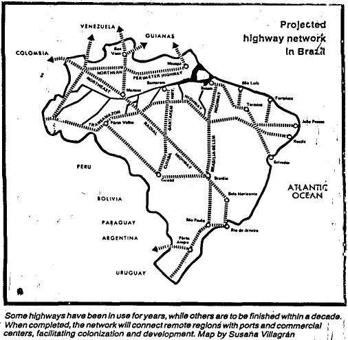
![]() The
trans-Amazonian highway was the first of many highways designed to
open up Amazonia. Hundreds of bulldozers, mechanical shovels,
graders, steamrollers , cultivators, compressors, and other huge
machines are operating day and night in the silent and grim forest.
The map below shows the magnitude of the road program for
Amazonia.
The
trans-Amazonian highway was the first of many highways designed to
open up Amazonia. Hundreds of bulldozers, mechanical shovels,
graders, steamrollers , cultivators, compressors, and other huge
machines are operating day and night in the silent and grim forest.
The map below shows the magnitude of the road program for
Amazonia.
![]() Brazil
hopes to open up this area, much as was done in the United States
with the homestead Act of 1862. This, as you know, opened up our mid
and far west. In Brazil, the government will grant duly qualified
applicants 160 acres of land. At the moment, this program is far from
being satisfactorily realized and many people from the Brazilian
northeast have had a go at it and have returned home disenchanted
with their prospects. A transcontinental railroad through Amazonia is
not contemplated at present, as a previous attempt at railroad
construction cost a "life per railroad tie"! (Madeira-Mamore Jungle
Railroad).
Brazil
hopes to open up this area, much as was done in the United States
with the homestead Act of 1862. This, as you know, opened up our mid
and far west. In Brazil, the government will grant duly qualified
applicants 160 acres of land. At the moment, this program is far from
being satisfactorily realized and many people from the Brazilian
northeast have had a go at it and have returned home disenchanted
with their prospects. A transcontinental railroad through Amazonia is
not contemplated at present, as a previous attempt at railroad
construction cost a "life per railroad tie"! (Madeira-Mamore Jungle
Railroad).
![]() The
greatest boom to development to date has been provided by the
Japanese farmers, who arrived in 1929 and settled in Acara, batter
known today as Tome-Acu, and who today raise most of the world's
black pepper. They also raise nutmeg, cloves, and vanilla. In
addition, Amazonia provides one of the world's richest botanical
complexes with more than 75,000 species of plants, many of which have
medicinal value. A woman, Nicole Maxwell, is a pioneer in this area
and has written a book on medicinal plants of the Amazon
tribes.
The
greatest boom to development to date has been provided by the
Japanese farmers, who arrived in 1929 and settled in Acara, batter
known today as Tome-Acu, and who today raise most of the world's
black pepper. They also raise nutmeg, cloves, and vanilla. In
addition, Amazonia provides one of the world's richest botanical
complexes with more than 75,000 species of plants, many of which have
medicinal value. A woman, Nicole Maxwell, is a pioneer in this area
and has written a book on medicinal plants of the Amazon
tribes.
![]() Amazonia,
it is said, lacks only people, capital, technology, and a spirit of
enterprise before it really comes into its own, but it needs, above
all, people. A Brazilian senator said in 1978 that "Amazonia is our
moon shot. Amazonia cannot wait. Brazil cannot stop."
Amazonia,
it is said, lacks only people, capital, technology, and a spirit of
enterprise before it really comes into its own, but it needs, above
all, people. A Brazilian senator said in 1978 that "Amazonia is our
moon shot. Amazonia cannot wait. Brazil cannot stop."
![]() At
least 85% of Amazonia is made up of that most complex of all
ecological formations, tropical lowland rain forest, and it is the
richest region biotechnically in the world. Although it accounts for
only 4% of the earth's land surface, it contains 50,000 species of
higher plants, one in five of such species on earth. It also boasts
of one in five of all bird species and contains the largest reptile
in the world, the 40 foot anaconda; also the largest insect, a 6"
beetle. Yet, Amazonia remains a scientific vacuum due to its lack of
thorough exploration.
At
least 85% of Amazonia is made up of that most complex of all
ecological formations, tropical lowland rain forest, and it is the
richest region biotechnically in the world. Although it accounts for
only 4% of the earth's land surface, it contains 50,000 species of
higher plants, one in five of such species on earth. It also boasts
of one in five of all bird species and contains the largest reptile
in the world, the 40 foot anaconda; also the largest insect, a 6"
beetle. Yet, Amazonia remains a scientific vacuum due to its lack of
thorough exploration.
![]() Amazonia
has the world's largest stock of timber and contains the world's most
extensive reserves of minerals, notably aluminum, tin, manganese,
iron, diamonds, and gold! Yet, it contributes less than 2% of
Brazil's gross national product. Thus, the basic problem is how to
develop these vast valuable resources. At one time, it was to be a
land without men for men without land, but it has been difficult to
persuade the impoverished farmers of the famine stricken northeast to
venture into the jungle and to develop it.
Amazonia
has the world's largest stock of timber and contains the world's most
extensive reserves of minerals, notably aluminum, tin, manganese,
iron, diamonds, and gold! Yet, it contributes less than 2% of
Brazil's gross national product. Thus, the basic problem is how to
develop these vast valuable resources. At one time, it was to be a
land without men for men without land, but it has been difficult to
persuade the impoverished farmers of the famine stricken northeast to
venture into the jungle and to develop it.
![]() On
July 3, 1978, an agreement was reached by the eight countries
bordering on the river (Amazon Cooperation Treaty). These countries
were Bolivia, Peru, Ecuador, Colombia, Venezuela, Brazil, the Guyanas
and Suriname. This treaty will provide for the promotion of the
economic growth of the area, the social well-being of its peoples,
and the need for ecological preservation.
On
July 3, 1978, an agreement was reached by the eight countries
bordering on the river (Amazon Cooperation Treaty). These countries
were Bolivia, Peru, Ecuador, Colombia, Venezuela, Brazil, the Guyanas
and Suriname. This treaty will provide for the promotion of the
economic growth of the area, the social well-being of its peoples,
and the need for ecological preservation.
![]() Our
Amazon trip really began at Iquitos, after we had flown to Lima, Peru
(overnight) and then on to Iquitos. Iquitos is a city deep in the
steamy reaches of the Peruvian Amazon, east of the Andes, and 4°
south of the equator. It is a jungle river port with a population of
approximately 200,000 and it is the central terminus for mahogany,
rosewood, animal hides, alligator skins, medicinal and dye plants,
cinnamon, the quininebearing cinchona bark, chickle for chewing gum,
Barbasco for insecticides, tropical aquarium fish, pet parakeets,
live monkeys for scientific experiments, and oil, a recent
development. Years ago, Iquitos was famous for its rubber production
but this went out, as in Manaus, when cuttings from the Brazilian
jungle were taken to the Kew Gardens in London, and then transferred
and replanted in Malaysia, where they thrived, and essentially
spelled the doom of the rubber industry in Brazil.
Our
Amazon trip really began at Iquitos, after we had flown to Lima, Peru
(overnight) and then on to Iquitos. Iquitos is a city deep in the
steamy reaches of the Peruvian Amazon, east of the Andes, and 4°
south of the equator. It is a jungle river port with a population of
approximately 200,000 and it is the central terminus for mahogany,
rosewood, animal hides, alligator skins, medicinal and dye plants,
cinnamon, the quininebearing cinchona bark, chickle for chewing gum,
Barbasco for insecticides, tropical aquarium fish, pet parakeets,
live monkeys for scientific experiments, and oil, a recent
development. Years ago, Iquitos was famous for its rubber production
but this went out, as in Manaus, when cuttings from the Brazilian
jungle were taken to the Kew Gardens in London, and then transferred
and replanted in Malaysia, where they thrived, and essentially
spelled the doom of the rubber industry in Brazil.
![]() No
roads lead to Iquitos, even though it is now one of Peru's largest
cities. It is located 2,400 miles from the mouth of the Amazon and
spreads across a narrow swampy peninsula 16 miles long and 3 miles
wide. Unfortunately, a severe tropical storm delayed our flight and
we arrived too late in the afternoon to see the city. However, from
what we saw in driving to the wharf from the airport, one can well
imagine that we did not miss very much. Nonetheless, I wish that I
might have seen at least its prominent points. Lack of rock in the
upper Amazon region long hindered Iquitos growth. Can you imagine an
LST loaded some 2,800 tons of gravel in Callao, on the Pacific,
sailed through the Panama Canal and up the Amazon to Iquitos, a 7,000
mile voyage between cities only 650 miles apart, to bring this
essential building commodity to Iquitos for construction purposes! It
reminded me of the fact that Singapore had recently barged in gravel
from Malaysia in order to build its new airport in the water
adjoining its old runway!
No
roads lead to Iquitos, even though it is now one of Peru's largest
cities. It is located 2,400 miles from the mouth of the Amazon and
spreads across a narrow swampy peninsula 16 miles long and 3 miles
wide. Unfortunately, a severe tropical storm delayed our flight and
we arrived too late in the afternoon to see the city. However, from
what we saw in driving to the wharf from the airport, one can well
imagine that we did not miss very much. Nonetheless, I wish that I
might have seen at least its prominent points. Lack of rock in the
upper Amazon region long hindered Iquitos growth. Can you imagine an
LST loaded some 2,800 tons of gravel in Callao, on the Pacific,
sailed through the Panama Canal and up the Amazon to Iquitos, a 7,000
mile voyage between cities only 650 miles apart, to bring this
essential building commodity to Iquitos for construction purposes! It
reminded me of the fact that Singapore had recently barged in gravel
from Malaysia in order to build its new airport in the water
adjoining its old runway!
![]() We
visited two Indian villages along the tributaries of the Amazon and
did so using our "Zodiac" which we will also employ on our Antarctica
trip. They are inflatable craft, designed by Jacques Cousteau and
powered by outboard marine engines (40 hp), and unsinkable due to
triple cylinder construction. They can carry conveniently up to ten
people and we had both wet (shoreline) and dry (dock) landings. Our
first trip was in a drenching downpour upriver to visit the Boca and
Huitoto tribes. Pat chose to make a shorter trip to a small primitive
town called Pevas. The Indians entertained us in the Community
Building (Moluca) which was a large round thatch-roofed structure.
Their tribal dances were dull compared to some others that I have
seen elsewhere in the world. We visited a small coca plantation and
learned how these "Low-land" Indians used it to deaden the pangs of
hunger while out on an all day hunt. Apparently, cocaine, used in
this manner, has no deleterious effects. In the case of the
"Highland" Indians, (Incas), the coca leaves enable them to perform
strenuous feats at high altitudes. The constant rain made walking in
the mud precarious, and by choosing to walk through the grass, I
invited an army of Chugoe or chiggers to invade my lower extremities,
and it was over three weeks before the reaction subsided, and only
after I individually dissected out the stinger. While walking in the
grass, I was totally unaware of the presence of chiggers and we had
not been forewarned of that possibility by the guide or the ship
surgeon.
We
visited two Indian villages along the tributaries of the Amazon and
did so using our "Zodiac" which we will also employ on our Antarctica
trip. They are inflatable craft, designed by Jacques Cousteau and
powered by outboard marine engines (40 hp), and unsinkable due to
triple cylinder construction. They can carry conveniently up to ten
people and we had both wet (shoreline) and dry (dock) landings. Our
first trip was in a drenching downpour upriver to visit the Boca and
Huitoto tribes. Pat chose to make a shorter trip to a small primitive
town called Pevas. The Indians entertained us in the Community
Building (Moluca) which was a large round thatch-roofed structure.
Their tribal dances were dull compared to some others that I have
seen elsewhere in the world. We visited a small coca plantation and
learned how these "Low-land" Indians used it to deaden the pangs of
hunger while out on an all day hunt. Apparently, cocaine, used in
this manner, has no deleterious effects. In the case of the
"Highland" Indians, (Incas), the coca leaves enable them to perform
strenuous feats at high altitudes. The constant rain made walking in
the mud precarious, and by choosing to walk through the grass, I
invited an army of Chugoe or chiggers to invade my lower extremities,
and it was over three weeks before the reaction subsided, and only
after I individually dissected out the stinger. While walking in the
grass, I was totally unaware of the presence of chiggers and we had
not been forewarned of that possibility by the guide or the ship
surgeon.
![]() It
is interesting that the Indian tribes we visited did not make much
use of fermented beverages except for and on ceremonial occasions,
but all of them used various hallucinogenic plants for the working
off of all sorts of frustrations and aggressions. For example, two
men would snort the powder, become semi-anesthetized, and then beat
each other up, neither feeling any pain in the process, but each
thereby lowering his level of animosity toward his rival or
antagonist. The powders are also used by the Shamans or witch doctors
to enable them to go into a trance and in so doing, cast out evil
spirits. The Indians live off the land with a variety of products but
mainly, they use Manioc or cassava or tapioca root which provides
their chief source of starch. This has to be treated before it is
edible and this is done in order to remove cyanide that is naturally
present in the plant.
It
is interesting that the Indian tribes we visited did not make much
use of fermented beverages except for and on ceremonial occasions,
but all of them used various hallucinogenic plants for the working
off of all sorts of frustrations and aggressions. For example, two
men would snort the powder, become semi-anesthetized, and then beat
each other up, neither feeling any pain in the process, but each
thereby lowering his level of animosity toward his rival or
antagonist. The powders are also used by the Shamans or witch doctors
to enable them to go into a trance and in so doing, cast out evil
spirits. The Indians live off the land with a variety of products but
mainly, they use Manioc or cassava or tapioca root which provides
their chief source of starch. This has to be treated before it is
edible and this is done in order to remove cyanide that is naturally
present in the plant.
![]() Another
fascinating ritual of the Indians is that of burial. The dead body is
cremated, the bones crushed into fine powder, mixed with a palatable
paste such as a banana or fruit paste, and then, this concoction is
consumed by the living descendants of the deceased. Only in this
manner is the deceased spirit liberated. If you want to threaten one,
you might say "I'll not eat your bones". They consider burial in the
ground barbarous.
Another
fascinating ritual of the Indians is that of burial. The dead body is
cremated, the bones crushed into fine powder, mixed with a palatable
paste such as a banana or fruit paste, and then, this concoction is
consumed by the living descendants of the deceased. Only in this
manner is the deceased spirit liberated. If you want to threaten one,
you might say "I'll not eat your bones". They consider burial in the
ground barbarous.
![]() The
Indians use the slash and burn method of agriculture and move on to
new areas when their soils are exhausted. They usually live in
communal groups of 60 to 100 inhabitants. Virtually all females over
13 were pregnant, despite the fact that we were told that they were
aware of a contraceptive plant that grew in their midst. In one of
the villages, half of the houses had a cross on them, indicating that
they had been semi-Christianized. I am sure they really had no idea
what it was all about, and no schools were operational anywhere,
although we were told that plans are in being to start some sort of a
Program of elementary education. Of the present 150 tribes, all are
linguistically different.
The
Indians use the slash and burn method of agriculture and move on to
new areas when their soils are exhausted. They usually live in
communal groups of 60 to 100 inhabitants. Virtually all females over
13 were pregnant, despite the fact that we were told that they were
aware of a contraceptive plant that grew in their midst. In one of
the villages, half of the houses had a cross on them, indicating that
they had been semi-Christianized. I am sure they really had no idea
what it was all about, and no schools were operational anywhere,
although we were told that plans are in being to start some sort of a
Program of elementary education. Of the present 150 tribes, all are
linguistically different.
![]() Fishing
was one of the activities that I enjoyed and I elected to try my hand
at it on three occasions. I was successful in one respect in that I
caught the largest piranha and catfish among the entire group. The
piranhas (red, white, and black- vegetarian) are very common, and
only the red and white are noted for their sharp teeth and the
rapidity with which they can consume their prey. On some occasions,
our bait was gone before our line reached the bottom. We used red
meat and cut up fish as our bait for the piranhas.
Fishing
was one of the activities that I enjoyed and I elected to try my hand
at it on three occasions. I was successful in one respect in that I
caught the largest piranha and catfish among the entire group. The
piranhas (red, white, and black- vegetarian) are very common, and
only the red and white are noted for their sharp teeth and the
rapidity with which they can consume their prey. On some occasions,
our bait was gone before our line reached the bottom. We used red
meat and cut up fish as our bait for the piranhas.
![]() Swimming
in the mid-Amazon was offered and I tried my hand at it. The water
was a deep brown and the current too swift for me to contend with. It
really wasn't much fun.
Swimming
in the mid-Amazon was offered and I tried my hand at it. The water
was a deep brown and the current too swift for me to contend with. It
really wasn't much fun.
![]() Perhaps
the most exciting event for me was the alligator hunt in total
darkness. Our Zodiac went up a small tributary and our naturalist
shone a brilliant light along the shore, looking for a pair of
brilliant red eyes, reflecting back his light. There were many to be
seen. The trick is to approach the pair of eyes slowly and quietly
and then, when they are within a hand's reach, to quickly grasp them
by the neck. In this manner and with some experience, it is not too
difficult to catch a small cayman (three to four feet) but larger
ones could not be caught in this manner unless one had a pair of
guerrilla hands. We all brought our catch back to the boat to be
placed in the swimming pool and to be photographed while we all
enjoyed a barbecue on the aft deck. It was a sumptuous affair with
adequate beer, wine, and spirits. The native Indians themselves
usually spear the alligators and poaching in this manner, while
illegal, is still carried on to a great extent by the local
poachers.
Perhaps
the most exciting event for me was the alligator hunt in total
darkness. Our Zodiac went up a small tributary and our naturalist
shone a brilliant light along the shore, looking for a pair of
brilliant red eyes, reflecting back his light. There were many to be
seen. The trick is to approach the pair of eyes slowly and quietly
and then, when they are within a hand's reach, to quickly grasp them
by the neck. In this manner and with some experience, it is not too
difficult to catch a small cayman (three to four feet) but larger
ones could not be caught in this manner unless one had a pair of
guerrilla hands. We all brought our catch back to the boat to be
placed in the swimming pool and to be photographed while we all
enjoyed a barbecue on the aft deck. It was a sumptuous affair with
adequate beer, wine, and spirits. The native Indians themselves
usually spear the alligators and poaching in this manner, while
illegal, is still carried on to a great extent by the local
poachers.
![]() Our
final stop was Manaus which necessitated our leaving the Amazon and
entering the Rio Negro, at which juncture, the socalled White Water
or truly Brown Water meets the Black water. This is rather a dramatic
sight to see and because of the rapid flow of the streams, each
maintains its individuality for a distance of 40 to 50 miles
downstream before they merge into a common color.
Our
final stop was Manaus which necessitated our leaving the Amazon and
entering the Rio Negro, at which juncture, the socalled White Water
or truly Brown Water meets the Black water. This is rather a dramatic
sight to see and because of the rapid flow of the streams, each
maintains its individuality for a distance of 40 to 50 miles
downstream before they merge into a common color.
![]() Our
voyage was concluded at Manaus, the capital of Amazonia, and a large
city some 1,000 miles from the Atlantic Ocean. It was named after a
local tribe of Indians called the Manaus tribe. The rubber boom at
the end of the Nineteenth Century brought fame and fortune to this
city and its prosperity brought people from all over the world. An
opulent, elegant opera house was built and Enrico Caruso, Anna
Pavlova, and Jenny Lind, the Nightingale, sang there. The Customs
House is beautiful and was designed and built in England and then
disassembled and brought piece by piece and reassembled in Manaus in
l909. Its prosperity was enhanced by the discovery of vulcanization,
which enabled raw rubber to develop the properties of elasticity,
strength, stability, and insensitivity to temperature variations, so
useful in industry, and particularly in the manufacture of automobile
tires. Manaus fortunes, however, were short-lived, when its rubber
plants were transported to Malaysia and grew there abundantly under
controlled conditions.
Our
voyage was concluded at Manaus, the capital of Amazonia, and a large
city some 1,000 miles from the Atlantic Ocean. It was named after a
local tribe of Indians called the Manaus tribe. The rubber boom at
the end of the Nineteenth Century brought fame and fortune to this
city and its prosperity brought people from all over the world. An
opulent, elegant opera house was built and Enrico Caruso, Anna
Pavlova, and Jenny Lind, the Nightingale, sang there. The Customs
House is beautiful and was designed and built in England and then
disassembled and brought piece by piece and reassembled in Manaus in
l909. Its prosperity was enhanced by the discovery of vulcanization,
which enabled raw rubber to develop the properties of elasticity,
strength, stability, and insensitivity to temperature variations, so
useful in industry, and particularly in the manufacture of automobile
tires. Manaus fortunes, however, were short-lived, when its rubber
plants were transported to Malaysia and grew there abundantly under
controlled conditions.
![]() In
1967, Manaus was declared a duty-free zone or city and no import
taxes were imposed on anything. This was done to persuade Brazilians,
tourists, merchants, etc., to visit this area, to develop it, and to
bring new life to the heart of Amazonia. While in Manaus, we stayed
at the Plaza Hotel, because it was air conditioned. The world famous
Tropical Hotel had lost its air conditioning and was intolerable to
stay at. We did, however, see the place and had dinner there but the
tropical heat and flying insects made our visit there a short one.
The Tropical Hotel is, when it is operating properly, an incredible
place to stay and covers more ground than any other hotel in the
world. It really opened up the Amazon to international tourism. It is
situated on the Rio Negro and from there, one can make river
expeditions up the river to visit the Igarapes or minor tributaries
where the Caboclos live. (Half-Portuguese, Half-Indian) Also while we
were in Manaus, we visited their Scientific Agricultural Research
Institutes where they are trying to develop better palm oil trees,
better rubber trees, and more productive guarana trees, the latter
tree producing a fruit from which the native soft drink is made. It
is rich in caffeine and I found it far superior to my taste to
Coca-Cola. I brought home some guarana powder with instructions on
how to make the soft drink, but the prescription was obviously wrong
and all my efforts have ended in disaster.
In
1967, Manaus was declared a duty-free zone or city and no import
taxes were imposed on anything. This was done to persuade Brazilians,
tourists, merchants, etc., to visit this area, to develop it, and to
bring new life to the heart of Amazonia. While in Manaus, we stayed
at the Plaza Hotel, because it was air conditioned. The world famous
Tropical Hotel had lost its air conditioning and was intolerable to
stay at. We did, however, see the place and had dinner there but the
tropical heat and flying insects made our visit there a short one.
The Tropical Hotel is, when it is operating properly, an incredible
place to stay and covers more ground than any other hotel in the
world. It really opened up the Amazon to international tourism. It is
situated on the Rio Negro and from there, one can make river
expeditions up the river to visit the Igarapes or minor tributaries
where the Caboclos live. (Half-Portuguese, Half-Indian) Also while we
were in Manaus, we visited their Scientific Agricultural Research
Institutes where they are trying to develop better palm oil trees,
better rubber trees, and more productive guarana trees, the latter
tree producing a fruit from which the native soft drink is made. It
is rich in caffeine and I found it far superior to my taste to
Coca-Cola. I brought home some guarana powder with instructions on
how to make the soft drink, but the prescription was obviously wrong
and all my efforts have ended in disaster.
![]() A
visit to the Military Zoo was also most interesting and we saw every
sort of animal, reptile, etc., that was to be found in the jungle.
This zoo was created in order to acquaint the soldiers who might have
to fight in the jungle with the type of animals that exist there in
order that they may be familiar with them and thus avoid this form of
danger.
A
visit to the Military Zoo was also most interesting and we saw every
sort of animal, reptile, etc., that was to be found in the jungle.
This zoo was created in order to acquaint the soldiers who might have
to fight in the jungle with the type of animals that exist there in
order that they may be familiar with them and thus avoid this form of
danger.
![]() We
flew home from Manaus to Miami on Varig, the National Brazilian
Airline, and it was certainly one of the best serviced airlines in my
experience. Good food and drinks, all free of charge. Before we
finally took off for Hartford, we flew to Tampa to spend an overnight
visit with my son Ted and his family.
We
flew home from Manaus to Miami on Varig, the National Brazilian
Airline, and it was certainly one of the best serviced airlines in my
experience. Good food and drinks, all free of charge. Before we
finally took off for Hartford, we flew to Tampa to spend an overnight
visit with my son Ted and his family.
![]() Someone
once said "It is a humbling experience, and surely a healthy one, to
enter a landscape that man has not been able to alter, to dominate
and to twist to his own purpose". Yet, today, the exploration for
minerals, wood products, medicinals and the development of farming of
all kinds seems destined to alter Amazonia as we know it today! The
new highway network will open up the entire area to immigration and
the assignment of the Indian tribes to reservations will no doubt
occur. I am glad that I saw Amazonia before all of this will have
happened.
Someone
once said "It is a humbling experience, and surely a healthy one, to
enter a landscape that man has not been able to alter, to dominate
and to twist to his own purpose". Yet, today, the exploration for
minerals, wood products, medicinals and the development of farming of
all kinds seems destined to alter Amazonia as we know it today! The
new highway network will open up the entire area to immigration and
the assignment of the Indian tribes to reservations will no doubt
occur. I am glad that I saw Amazonia before all of this will have
happened.
With Love,
DAD
CEJ/ngb
Below is a bit from our captain about the navigational
aspects of the journey.
(By Captain H. Aye)
![]() Coming
from the Caribbean we enter the Amazon through the north entrance
173nm without local Brazilian pilots.
Coming
from the Caribbean we enter the Amazon through the north entrance
173nm without local Brazilian pilots.
![]() The
Amazon is not merely the largest river on earth, it is a moving fresh
water sea that dwarfs in size any other river. Nearly one fifth of
all the river water in the world is flowing in the Amazon. The
immensity of this 4,000-mile-long rolling flood is comprehensible
only by a string of staggering comparisons. The volume of water
discharges into the sea by the Amazon is 7,000,000 cubic feet per
second which could fill the whole of Lake Ontario in about three
hours. The outflow is nearly twelve times greater than the Nile's.
Ten Amazon tributaries are larger than the Mississippi. Totally there
are more than one thousand tributaries, seventeen of which are more
than a thousand miles long. The mouth of the river covers the same
area as between London and Paris.
The
Amazon is not merely the largest river on earth, it is a moving fresh
water sea that dwarfs in size any other river. Nearly one fifth of
all the river water in the world is flowing in the Amazon. The
immensity of this 4,000-mile-long rolling flood is comprehensible
only by a string of staggering comparisons. The volume of water
discharges into the sea by the Amazon is 7,000,000 cubic feet per
second which could fill the whole of Lake Ontario in about three
hours. The outflow is nearly twelve times greater than the Nile's.
Ten Amazon tributaries are larger than the Mississippi. Totally there
are more than one thousand tributaries, seventeen of which are more
than a thousand miles long. The mouth of the river covers the same
area as between London and Paris.
![]() Over
a good part of its course, the main river averages one hundred feet
in depth, enabling ocean-going vessels to navigate 2,300 miles
upstream, and nearly across the continent, to the port of Iquitos,
Peru, at the eastern edge of the Andes. Even though the river a
thousand miles inland is often 7 miles wide (and that can swell to 35
miles during the wet season) the navigable channel with the required
depth for 'M.V. WORLD DISCOVERER' is for longer distances only 30 to
50 yards wide. This refers especially to the upper Amazon between
Manaus and Iquitos. Every third ship runs aground on the
Amazon.
Over
a good part of its course, the main river averages one hundred feet
in depth, enabling ocean-going vessels to navigate 2,300 miles
upstream, and nearly across the continent, to the port of Iquitos,
Peru, at the eastern edge of the Andes. Even though the river a
thousand miles inland is often 7 miles wide (and that can swell to 35
miles during the wet season) the navigable channel with the required
depth for 'M.V. WORLD DISCOVERER' is for longer distances only 30 to
50 yards wide. This refers especially to the upper Amazon between
Manaus and Iquitos. Every third ship runs aground on the
Amazon.
![]() But
how to trace this navigable channel under the muddy surface of the
Amazon river? Nowhere along the river are there lighthouses, beacons,
or buoys to show the way - to give assistance. In addition the real
depth of the water is always unforeseeable.
But
how to trace this navigable channel under the muddy surface of the
Amazon river? Nowhere along the river are there lighthouses, beacons,
or buoys to show the way - to give assistance. In addition the real
depth of the water is always unforeseeable.
![]() In
considering all of this, it is quite a challenge for a Captain to
conduct a vessel safely and on time through the swirling surface of
this river. The adventure cruises of the 'M.V. WORLD DISCOVERER'
start either at Santander or Belem upstream. As Captain, I have
successfully negotiated 11 Amazon journeys since 1977. The bridge of
'M.V. WORLD DISCOVERER' was kept on twenty-four hour alert to sight
hazards capable of disabling a vessel: hardwood logs that could blunt
the ship's propellers, splayed tree trunks that could damage the hull
plating, drifting islands of dense vegetation that could slide
beneath the vessel and snarl the propellers.
In
considering all of this, it is quite a challenge for a Captain to
conduct a vessel safely and on time through the swirling surface of
this river. The adventure cruises of the 'M.V. WORLD DISCOVERER'
start either at Santander or Belem upstream. As Captain, I have
successfully negotiated 11 Amazon journeys since 1977. The bridge of
'M.V. WORLD DISCOVERER' was kept on twenty-four hour alert to sight
hazards capable of disabling a vessel: hardwood logs that could blunt
the ship's propellers, splayed tree trunks that could damage the hull
plating, drifting islands of dense vegetation that could slide
beneath the vessel and snarl the propellers.
![]() In
total 4 pilots were used. From Belem to Manaus the two Brazilian
Pilots, and for the upper Amazon from Manaus to Iquitos two Peruvian
Pilots. They do their jobs well and patiently endure all our requests
- like unscheduled expedition stops - morning/dawn anchorages for
bird watchers and spontaneous rubber boat landings, in order to
provide our passengers with new excitement and new adventures, as
promised in the Society Expeditions brochure . . .
In
total 4 pilots were used. From Belem to Manaus the two Brazilian
Pilots, and for the upper Amazon from Manaus to Iquitos two Peruvian
Pilots. They do their jobs well and patiently endure all our requests
- like unscheduled expedition stops - morning/dawn anchorages for
bird watchers and spontaneous rubber boat landings, in order to
provide our passengers with new excitement and new adventures, as
promised in the Society Expeditions brochure . . .
![]() During
the last days of our upstream voyage, we ran into an extremely low
water situation. Within 5 days the water level fell to about 8 feet.
Three feet more and our downstream voyage would have been impossible.
In order to get the minimum possible draft on our way back, all
ballast water was discharged and only a minimum amount of fresh water
was taken on. This preventive measure was supported by a very
reasonable consumption of water on board. Nevertheless, we had to
rely on the water level of the freshwater river Jutai and Altar do
Chao where finally freshwater could be resupplied. All this must be
real expedition!
During
the last days of our upstream voyage, we ran into an extremely low
water situation. Within 5 days the water level fell to about 8 feet.
Three feet more and our downstream voyage would have been impossible.
In order to get the minimum possible draft on our way back, all
ballast water was discharged and only a minimum amount of fresh water
was taken on. This preventive measure was supported by a very
reasonable consumption of water on board. Nevertheless, we had to
rely on the water level of the freshwater river Jutai and Altar do
Chao where finally freshwater could be resupplied. All this must be
real expedition!
![]() The
number of shallow water areas increased rapidly. Several daylight
passages were necessary, 12 in total, often with no more than 6 feet
of water below the keel. Considering the fact that sandbanks,
sometimes 8 feet high in depth, were bulldozed along the bottom by
strong currents creating ripples of course sand that invalidate
navigational maps, we had sometimes to anchor and take a superlaunch
to take surroundings in order to trace the navigable channel. The
lowest depths were always experienced when passing a mouth of a
tributary or crossing the main river's main course.
The
number of shallow water areas increased rapidly. Several daylight
passages were necessary, 12 in total, often with no more than 6 feet
of water below the keel. Considering the fact that sandbanks,
sometimes 8 feet high in depth, were bulldozed along the bottom by
strong currents creating ripples of course sand that invalidate
navigational maps, we had sometimes to anchor and take a superlaunch
to take surroundings in order to trace the navigable channel. The
lowest depths were always experienced when passing a mouth of a
tributary or crossing the main river's main course.
![]() Precise
navigation is essential throughout the day and night. Hand steering
is necessary for the whole of the Amazon journey. The helmsman's
concentration was really proven - a wrong execution of a sudden order
would have taken our ship right into the jungle, especially when we
have to sail so close to the river bank. Also there are islands
growing and islands floating away - like Aranapu which has gone,
together with 10,000 monkeys. The navigation charts cannot be altered
as quickly as these islands come and go. It is a help to navigation
and anchoring when there is a full moon but that occurs only for a
few days each month.
Precise
navigation is essential throughout the day and night. Hand steering
is necessary for the whole of the Amazon journey. The helmsman's
concentration was really proven - a wrong execution of a sudden order
would have taken our ship right into the jungle, especially when we
have to sail so close to the river bank. Also there are islands
growing and islands floating away - like Aranapu which has gone,
together with 10,000 monkeys. The navigation charts cannot be altered
as quickly as these islands come and go. It is a help to navigation
and anchoring when there is a full moon but that occurs only for a
few days each month.
![]() The
pilots have known the river for over 20 years. Nearly every tree or
side stream or even an Indian hut become markers for navigation and
it is not necessary for them to refer to the nautical charts. At
night time through the binoculars the pilots will watch the surface
of the water which will show them that where the most current is
running - there will be a channel. When it becomes necessary for a
daylight passage due to shallow water, both pilots will be on the
bridge assisting one-another. Every three or four minutes the course
has to be changed by 5 degrees.
The
pilots have known the river for over 20 years. Nearly every tree or
side stream or even an Indian hut become markers for navigation and
it is not necessary for them to refer to the nautical charts. At
night time through the binoculars the pilots will watch the surface
of the water which will show them that where the most current is
running - there will be a channel. When it becomes necessary for a
daylight passage due to shallow water, both pilots will be on the
bridge assisting one-another. Every three or four minutes the course
has to be changed by 5 degrees.
![]() Each
year going upstream it is necessary that new channels have to be
checked with the ship's superlaunch. Soundings have to be taken ahead
to find a safe passage across the river bed. The current runs at
between 2.5 and 6 knots. All anchoring grounds have held good, no
rocks and no stones around. Wind and weather have remained virtually
unchanged. A rain shower with lightning lasts only thirty minutes -
that's all. There is no twilight, immediately after sunset it is
completely dark and from then the night shift takes over for the next
twelve hours. This is the time of mosquitoes, bats, moths, fire
flies, and caymens. Being just south of the Equator it is possible to
see the Southern Cross about two hours before sunrise.
Each
year going upstream it is necessary that new channels have to be
checked with the ship's superlaunch. Soundings have to be taken ahead
to find a safe passage across the river bed. The current runs at
between 2.5 and 6 knots. All anchoring grounds have held good, no
rocks and no stones around. Wind and weather have remained virtually
unchanged. A rain shower with lightning lasts only thirty minutes -
that's all. There is no twilight, immediately after sunset it is
completely dark and from then the night shift takes over for the next
twelve hours. This is the time of mosquitoes, bats, moths, fire
flies, and caymens. Being just south of the Equator it is possible to
see the Southern Cross about two hours before sunrise.
The keywords of an Amazon expedition cruise
are:
![]() 99%
Expedition
99%
Expedition
![]() Adventure
Adventure
![]() Challenge
Challenge
![]() Fun
Fun
![]() nice, friendly
Indios, wildlife
nice, friendly
Indios, wildlife
and the memories of the happy friendly faces of the residents of this mighty river, and the birds and the dolphins and the fish and the monkeys and the caymen and and and . . .
and to belong to only a handful of people from all over the world (less than 15,000) who have ever explored the River Amazon between Belem and Iquitos.
November, 1989
Captain Aye
Master, "World Discoverer"
or