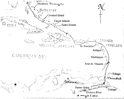
Venezuela and the Caribbean
May - June 1990
Dear Cha-Wel-Dor-Sue:
![]() Our
journey began with a flight of two hours and fifty minutes from
Miami, Florida to Miquetia, Venezuela, the airport for Caracas, the
capital. It is only four kilometers from LaGuaira, the port I landed
at in 1938 as the Ship's Surgeon on the Grace Line's Santa Rosa, 52
years ago, filling in an interim between my appointments at the
Memorial Hospital in New York City and the Mayo Clinic in Rochester,
Minnesota.
Our
journey began with a flight of two hours and fifty minutes from
Miami, Florida to Miquetia, Venezuela, the airport for Caracas, the
capital. It is only four kilometers from LaGuaira, the port I landed
at in 1938 as the Ship's Surgeon on the Grace Line's Santa Rosa, 52
years ago, filling in an interim between my appointments at the
Memorial Hospital in New York City and the Mayo Clinic in Rochester,
Minnesota.
![]() The
primary reason for the Venezuelan portion of the "Expedition" was to
visit Angel Falls, the highest waterfall in the world, 3,212 feet
high. It begins in the Guyana Shield or Grande Sabana or, as it is
commonly called, the highlands, where the famous Mesas or Tepuis are
seen. These table-top formations are like our western Mesas except
they are covered with lush vegetation and are among the oldest rocks
on earth. Fortunately, our Boeing 727 carried only 38 people and
virtually all of us had access to a window for photography. Also, the
day was clear, except for occasional white clouds hovering near the
summit. As a consequence, we were able to secure beautiful views of
the Falls, and perhaps some good photographs. After viewing the
Falls, we landed at Canaima Falls and Park, a national park preserved
by the government for its unique geological formations, and equipped
with cabin type accommodations for visitors. There is a small lake at
the foot of the Falls and a long canoe-type of boat powered by an
outboard was used to take us to the very foot of the Falls. One of
the remarkable features of the Falls was the unusual rusty color of
the water, which I assumed erroneously to be due to its high iron
content. Actually, it was due to the high content of tannin, as in
tea, resulting from the decomposition of vegetable matter.
The
primary reason for the Venezuelan portion of the "Expedition" was to
visit Angel Falls, the highest waterfall in the world, 3,212 feet
high. It begins in the Guyana Shield or Grande Sabana or, as it is
commonly called, the highlands, where the famous Mesas or Tepuis are
seen. These table-top formations are like our western Mesas except
they are covered with lush vegetation and are among the oldest rocks
on earth. Fortunately, our Boeing 727 carried only 38 people and
virtually all of us had access to a window for photography. Also, the
day was clear, except for occasional white clouds hovering near the
summit. As a consequence, we were able to secure beautiful views of
the Falls, and perhaps some good photographs. After viewing the
Falls, we landed at Canaima Falls and Park, a national park preserved
by the government for its unique geological formations, and equipped
with cabin type accommodations for visitors. There is a small lake at
the foot of the Falls and a long canoe-type of boat powered by an
outboard was used to take us to the very foot of the Falls. One of
the remarkable features of the Falls was the unusual rusty color of
the water, which I assumed erroneously to be due to its high iron
content. Actually, it was due to the high content of tannin, as in
tea, resulting from the decomposition of vegetable matter.
![]() We
spent the night in Ciudad Guayana, a twin city complex lying on both
sides of the Orinoco River (San Felix on the north side and Puerto
Orduz on the south side). It is a city only 35 years old of some
60,000 people and growing rapidly due to the great abundance of
metals such as gold, various alloys and particularly iron, which are
found in the immediate area. In fact, the largest deposit of the
richest iron ore in the world is nearby and I have a picture of a
"mountain" of processed iron ore awaiting transfer via conveyor belts
to ships to be taken all over the world, especially to Japan and the
United States. Bauxite is also mined in abundance here.
We
spent the night in Ciudad Guayana, a twin city complex lying on both
sides of the Orinoco River (San Felix on the north side and Puerto
Orduz on the south side). It is a city only 35 years old of some
60,000 people and growing rapidly due to the great abundance of
metals such as gold, various alloys and particularly iron, which are
found in the immediate area. In fact, the largest deposit of the
richest iron ore in the world is nearby and I have a picture of a
"mountain" of processed iron ore awaiting transfer via conveyor belts
to ships to be taken all over the world, especially to Japan and the
United States. Bauxite is also mined in abundance here.
![]() Our
"Birding" expedition this morning began at 6:30 via Zodiac along a
tributary of the Orinoco River and some 45 species of birds were
seen. River dolphins were also noted. My interest was largely in the
Indian or native populations and their means of survival, agriculture
and fishing. Apparently, fishing can be accomplished by hook and
line, netting, and spear-fishing.
Our
"Birding" expedition this morning began at 6:30 via Zodiac along a
tributary of the Orinoco River and some 45 species of birds were
seen. River dolphins were also noted. My interest was largely in the
Indian or native populations and their means of survival, agriculture
and fishing. Apparently, fishing can be accomplished by hook and
line, netting, and spear-fishing.
![]() One
of the unusual features of traveling the Society Expeditions is that
you are exposed to a series of lectures by experts and so
essentially, it is a learning experience as contrasted to simply
cruising among the islands. Our first lecture was by John Harwood, a
British botanist who calls Manaus, Brazil his home and he is in
Brazil primary to study the problems of creating alternate energy
sources to replace our depleting fossil fuels. He would like to find
reproducible sources of energy from the vast Amazonian biomass
without destroying the Tropical Forest. It is a tremendous challenge,
of course. In his remarks, he repeated the classic description of a
Tropical Rain Forest and this is one in which there is essentially no
dry season of any kind and he particularly mentioned the various
categories of canopies. On the ground or lowest level are the leaf
litter and the decomposing vegetative matter and this area is
occupied largely by fungi and bacteria. It is thin, fragile, and
contains very little humus. There is very little light here and
photosynthesis is at an extremely low level. Above this are the
low-growing shade trees which may reach as high as 20 or 30 feet,
such as the cacao (chocolate) which grow under higher trees such as
the rubber tree and the chickle tree. These may reach 50 feet or so.
Above them are the so called emergent trees which tower 100 feet or
more and include such trees as the Brazil nut and the kapok trees.
From the branches of many of the trees, epiphytes or air-plants were
seen and this includes the vast group of orchids, and many
bromeliads.There are many llanos or vines which encircle the trees
and which drop down like long ropes resembling the type such as
Tarzan used to swing on from tree to tree. These are the so-called
philodendrons or giant philodendrons.
One
of the unusual features of traveling the Society Expeditions is that
you are exposed to a series of lectures by experts and so
essentially, it is a learning experience as contrasted to simply
cruising among the islands. Our first lecture was by John Harwood, a
British botanist who calls Manaus, Brazil his home and he is in
Brazil primary to study the problems of creating alternate energy
sources to replace our depleting fossil fuels. He would like to find
reproducible sources of energy from the vast Amazonian biomass
without destroying the Tropical Forest. It is a tremendous challenge,
of course. In his remarks, he repeated the classic description of a
Tropical Rain Forest and this is one in which there is essentially no
dry season of any kind and he particularly mentioned the various
categories of canopies. On the ground or lowest level are the leaf
litter and the decomposing vegetative matter and this area is
occupied largely by fungi and bacteria. It is thin, fragile, and
contains very little humus. There is very little light here and
photosynthesis is at an extremely low level. Above this are the
low-growing shade trees which may reach as high as 20 or 30 feet,
such as the cacao (chocolate) which grow under higher trees such as
the rubber tree and the chickle tree. These may reach 50 feet or so.
Above them are the so called emergent trees which tower 100 feet or
more and include such trees as the Brazil nut and the kapok trees.
From the branches of many of the trees, epiphytes or air-plants were
seen and this includes the vast group of orchids, and many
bromeliads.There are many llanos or vines which encircle the trees
and which drop down like long ropes resembling the type such as
Tarzan used to swing on from tree to tree. These are the so-called
philodendrons or giant philodendrons.
![]() The
fertility of this area of the Orinoco arises largely from the erosion
of the Andes Mountains which lie to the west and which carries down
material rich in essential inorganic elements such as calcium,
phosphorus, magnesium, sodium and zinc. This is contrasted with the
soil of the Savannas, which arise by virtue of erosion from the Mesas
or old rocks, some of which are assumed to be over two billion years
old. Most of the essential minerals have been leached out of this
soil over periods of time and therefore, it is not as fertile as that
which has arisen in the Andes.
The
fertility of this area of the Orinoco arises largely from the erosion
of the Andes Mountains which lie to the west and which carries down
material rich in essential inorganic elements such as calcium,
phosphorus, magnesium, sodium and zinc. This is contrasted with the
soil of the Savannas, which arise by virtue of erosion from the Mesas
or old rocks, some of which are assumed to be over two billion years
old. Most of the essential minerals have been leached out of this
soil over periods of time and therefore, it is not as fertile as that
which has arisen in the Andes.
![]() On
our very first afternoon on the river, we were exposed to an
"Expedition" after whom the company "Society Expeditions" was named.
This consists of a challenge that the ship and its crew and
administrative staff had never done before. No one in these instances
has gone ahead and made plans for the event and the area had not been
scouted. This expedition was conceived by the staff on a previous
trip some four days ago when it was realized that a trip through a
typical Tropical Rain Forest was possible. The water in the savannas
or plains area along the tributaries was high and using a Zodiac, one
could get to the higher areas topped by tall trees and virtually
impenetrable. There is nothing cultivated there and it is simply
primeval forest. As we were told, we could do this "ad lib" with a
machete, a killing task, or else find a native who perhaps may know a
trail through the Rain Forest, if indeed one exists. And so, we
ventured out to the very end of the water line until we found a shack
and a native who was willing to guide us to a path he used to enter
the area to cut firewood. As it was described in the lecture this
morning, the area was extremely dark and one had to wait for one's
eyes to adjust before proceeding forward. Even looking up toward the
sky, one could only see the sky as a very fine lacework of light and
all sorts of vegetation, trees, insects surrounded us. A dark cloud
passed over and we were soon drenched despite the thick canopy of
overhanging branches and leaves. It was an arduous walk and in fact,
a stress test without an electrocardiogram. However, I managed to act
as a tail-light at the end of the line. Some angina was present but
there was no retreat. It reminded me of a Japanese quotation "He who
contemplates climbing Mount Fuji is a fool, but he who climbs it is
twice a fool." I will remember this the next time a trip in a typical
Rain Forest comes up.
On
our very first afternoon on the river, we were exposed to an
"Expedition" after whom the company "Society Expeditions" was named.
This consists of a challenge that the ship and its crew and
administrative staff had never done before. No one in these instances
has gone ahead and made plans for the event and the area had not been
scouted. This expedition was conceived by the staff on a previous
trip some four days ago when it was realized that a trip through a
typical Tropical Rain Forest was possible. The water in the savannas
or plains area along the tributaries was high and using a Zodiac, one
could get to the higher areas topped by tall trees and virtually
impenetrable. There is nothing cultivated there and it is simply
primeval forest. As we were told, we could do this "ad lib" with a
machete, a killing task, or else find a native who perhaps may know a
trail through the Rain Forest, if indeed one exists. And so, we
ventured out to the very end of the water line until we found a shack
and a native who was willing to guide us to a path he used to enter
the area to cut firewood. As it was described in the lecture this
morning, the area was extremely dark and one had to wait for one's
eyes to adjust before proceeding forward. Even looking up toward the
sky, one could only see the sky as a very fine lacework of light and
all sorts of vegetation, trees, insects surrounded us. A dark cloud
passed over and we were soon drenched despite the thick canopy of
overhanging branches and leaves. It was an arduous walk and in fact,
a stress test without an electrocardiogram. However, I managed to act
as a tail-light at the end of the line. Some angina was present but
there was no retreat. It reminded me of a Japanese quotation "He who
contemplates climbing Mount Fuji is a fool, but he who climbs it is
twice a fool." I will remember this the next time a trip in a typical
Rain Forest comes up.
![]() Being
invited to the Captain's table is an honor, but it is becoming
commonplace. because Pat and I have been on so many Society
Expeditions. We are almost automatically invited to his table.
Tonight was no exception and it was a wonderful experience. We could
be convivial and I could ask him who were his role models as ship's
captains. Finally, it came out that it was Captain Cook, who sailed
around the world without maps and without modern aids and who,
unfortunately, ended his life being killed by natives in Hawaii. He
told us many of the stories of this little ship and his other ship
the "Society Discoverer" and of his many trips literally to all parts
of the world. I doubt very much that there is any captain sailing any
vessel today who has had such an extremely varied experience. He has
twice done the Northwest Passage and has been to Antarctica 57 times
but there is hardly a place in this world that he has not explored
and, indeed, it was he who took this little red ship to a Russian
port in Siberia without permission from the U.S. authorities and
without the aid of any charts or navigational aids from the Russians
except for a tugboat that greeted him when he was close to the shore.
Captain Aye is a man to be admired and he is much like a pioneer
facing the unknown who walks forward unflinchingly, knowing that he's
had a solid background in ship handling and navigation and with a
good crew, can usually master any problem at sea.
Being
invited to the Captain's table is an honor, but it is becoming
commonplace. because Pat and I have been on so many Society
Expeditions. We are almost automatically invited to his table.
Tonight was no exception and it was a wonderful experience. We could
be convivial and I could ask him who were his role models as ship's
captains. Finally, it came out that it was Captain Cook, who sailed
around the world without maps and without modern aids and who,
unfortunately, ended his life being killed by natives in Hawaii. He
told us many of the stories of this little ship and his other ship
the "Society Discoverer" and of his many trips literally to all parts
of the world. I doubt very much that there is any captain sailing any
vessel today who has had such an extremely varied experience. He has
twice done the Northwest Passage and has been to Antarctica 57 times
but there is hardly a place in this world that he has not explored
and, indeed, it was he who took this little red ship to a Russian
port in Siberia without permission from the U.S. authorities and
without the aid of any charts or navigational aids from the Russians
except for a tugboat that greeted him when he was close to the shore.
Captain Aye is a man to be admired and he is much like a pioneer
facing the unknown who walks forward unflinchingly, knowing that he's
had a solid background in ship handling and navigation and with a
good crew, can usually master any problem at sea.
![]() Toward
the end of dinner, he brought out a bottle of German champagne (Furst
Metternich) and both Pat and I thoroughly enjoyed it. For me, it was
a first experience with a semi-sweet champagne and reminded me of the
Italian Asti Spumante.
Toward
the end of dinner, he brought out a bottle of German champagne (Furst
Metternich) and both Pat and I thoroughly enjoyed it. For me, it was
a first experience with a semi-sweet champagne and reminded me of the
Italian Asti Spumante.
![]() As
we proceeded down the Orinoco River, we entered the Delta and I
presume it is a little like the Deltas in the Mississippi, in the
Mekong and the Nile, where the large main river breaks up or branches
into many smaller rivers while still maintaining a primary entity.
These areas are largely flood plains, rich in silt, and very fertile.
Vegetation abounds and there are many beautiful straight palm trees,
the well-known Morichi, from which fine streamers or fibers are cut
and woven into hammocks or baskets. The Warao tribe of Amer-Indians
or the so-called canoe people live in this area and we visited their
village of Curiapo. They are, like many primitive people,
space-oriented and when asking a stranger about his home village,
address them with the question "And from which direction do you
come?" Time for them is not a continuum but is cyclic. As we were
told, we western people are historically oriented and think of time
as a continuum. The Warao people use "reciprocal barter" as a form of
trade. The idea of a cash economy or its equivalent has not yet
reached this remote area of Venezuela.
As
we proceeded down the Orinoco River, we entered the Delta and I
presume it is a little like the Deltas in the Mississippi, in the
Mekong and the Nile, where the large main river breaks up or branches
into many smaller rivers while still maintaining a primary entity.
These areas are largely flood plains, rich in silt, and very fertile.
Vegetation abounds and there are many beautiful straight palm trees,
the well-known Morichi, from which fine streamers or fibers are cut
and woven into hammocks or baskets. The Warao tribe of Amer-Indians
or the so-called canoe people live in this area and we visited their
village of Curiapo. They are, like many primitive people,
space-oriented and when asking a stranger about his home village,
address them with the question "And from which direction do you
come?" Time for them is not a continuum but is cyclic. As we were
told, we western people are historically oriented and think of time
as a continuum. The Warao people use "reciprocal barter" as a form of
trade. The idea of a cash economy or its equivalent has not yet
reached this remote area of Venezuela.
![]() Later
in the morning, we drove our Zodiacs up the Rio Arature where we were
scheduled to ride in some homemade dugouts. However, the boats did
not arrive and heavy torrents of rain fell and we were just as glad
not to be exposed to this dangerous experience. Never have I been so
wet, even when I was swimming underwater!
Later
in the morning, we drove our Zodiacs up the Rio Arature where we were
scheduled to ride in some homemade dugouts. However, the boats did
not arrive and heavy torrents of rain fell and we were just as glad
not to be exposed to this dangerous experience. Never have I been so
wet, even when I was swimming underwater!
![]() After
we left the mouth of the Orinoco, and it is the third largest river
in South America, we set sail for the island of Trinidad which is
just seven miles off the northeast coast of Venezuela, across the Bay
of Paria. The cruising was a bit rough and I chose to omit eating in
the dining room and to heavily sedate myself to assure a sound
night's sleep. Pat, however, ventured into the dining room and
successfully passed the evening with the few other guests who decided
to give it a whirl.
After
we left the mouth of the Orinoco, and it is the third largest river
in South America, we set sail for the island of Trinidad which is
just seven miles off the northeast coast of Venezuela, across the Bay
of Paria. The cruising was a bit rough and I chose to omit eating in
the dining room and to heavily sedate myself to assure a sound
night's sleep. Pat, however, ventured into the dining room and
successfully passed the evening with the few other guests who decided
to give it a whirl.
![]() We
entered the Republic of Trinidad, Tobago, by landing at a wharf in
Port of Spain, the capital. I had been here roughly some 40 years
ago, having flown from Barbados in a small four passenger Widgeon
amphibian plane equipped with twin Pratt and Whitney engines.
Trinidad, as I recalled it, was the most cosmopolitan city I had ever
visited for the diversity of its peoples. It was largely populated by
the descendants of black slaves from Africa, Hindus and Moslems from
the Far East, (India), with their mosques and temples, and Chinese
who came as indentured laborers for five years to work in the cane
fields. Trinidad, incidentally, was named by Christopher Columbus on
his third trip to America in 1498 when he first saw three hills on
the south coast of the island and called them "Trinity". Their
coinage is the decimal system and the U.S. dollar equaled 4.5
T.T.
We
entered the Republic of Trinidad, Tobago, by landing at a wharf in
Port of Spain, the capital. I had been here roughly some 40 years
ago, having flown from Barbados in a small four passenger Widgeon
amphibian plane equipped with twin Pratt and Whitney engines.
Trinidad, as I recalled it, was the most cosmopolitan city I had ever
visited for the diversity of its peoples. It was largely populated by
the descendants of black slaves from Africa, Hindus and Moslems from
the Far East, (India), with their mosques and temples, and Chinese
who came as indentured laborers for five years to work in the cane
fields. Trinidad, incidentally, was named by Christopher Columbus on
his third trip to America in 1498 when he first saw three hills on
the south coast of the island and called them "Trinity". Their
coinage is the decimal system and the U.S. dollar equaled 4.5
T.T.
![]() The
morning's tour of Port of Spain was far less interesting than the one
I made a long time ago and, on this occasion, consisted of a city
tour. Perhaps it was because I saw it many years ago through the wide
open amazed eyes of a young man, viewing what was then for me the
most unusual and cosmopolitan city in the world. Then I recall the
many black people of African origin, the Hindus with their small
houses and their flags flying in front to commemorate religious
ceremonies or moments in their lives, Muslims in their mosques, and
finally, a variety of descendants from the Spanish, the Portuguese
and the French and the British settlers. Today, I understand that
they are all Trinidadians and are less ethnologically differentiated.
We also drove over the mountain to Maracas Bay, a beautiful small
white sand beach on the North Coast of Trinidad.
The
morning's tour of Port of Spain was far less interesting than the one
I made a long time ago and, on this occasion, consisted of a city
tour. Perhaps it was because I saw it many years ago through the wide
open amazed eyes of a young man, viewing what was then for me the
most unusual and cosmopolitan city in the world. Then I recall the
many black people of African origin, the Hindus with their small
houses and their flags flying in front to commemorate religious
ceremonies or moments in their lives, Muslims in their mosques, and
finally, a variety of descendants from the Spanish, the Portuguese
and the French and the British settlers. Today, I understand that
they are all Trinidadians and are less ethnologically differentiated.
We also drove over the mountain to Maracas Bay, a beautiful small
white sand beach on the North Coast of Trinidad.
![]() The
highlight of the day, however, was a visit to the Caroni River Bird
Sanctuary and, on this occasion, we were escorted by Dr. Winston
Nathan, a brilliant Indian ornithologist and naturalist. He explained
the complex ecology of this area, discussing the various types of
mangrove trees and of the life that exists along the banks of the
canals. We actually saw a four-eyed fish with two eyes above the
water and two below. The highlight was seeing the Scarlet Ibis, a
fairly large bird of intense scarlet color except for a small area of
black on the tip of the primaries. It is one of the most beautiful
birds I have seen, especially when it is seen by reflected sunlight
and the "Birders" were thrilled to see it. The park is a natural
treasure and some 86 varieties of birds live there. We also saw the
remarkable Potoo, the finest example I have ever seen of mimicry,
camouflage and masquerade and of simple deception! It is a bird that
sits at the top of a stump and looks every bit a part of the stump.
Its feathers match the color of the stump and it appears to literally
grow out of the stump. It was not until I saw its head move that I
was convinced that it was indeed a bird and there were a few who
happened to catch a view of its eye as it opened its eye for a
moment.
The
highlight of the day, however, was a visit to the Caroni River Bird
Sanctuary and, on this occasion, we were escorted by Dr. Winston
Nathan, a brilliant Indian ornithologist and naturalist. He explained
the complex ecology of this area, discussing the various types of
mangrove trees and of the life that exists along the banks of the
canals. We actually saw a four-eyed fish with two eyes above the
water and two below. The highlight was seeing the Scarlet Ibis, a
fairly large bird of intense scarlet color except for a small area of
black on the tip of the primaries. It is one of the most beautiful
birds I have seen, especially when it is seen by reflected sunlight
and the "Birders" were thrilled to see it. The park is a natural
treasure and some 86 varieties of birds live there. We also saw the
remarkable Potoo, the finest example I have ever seen of mimicry,
camouflage and masquerade and of simple deception! It is a bird that
sits at the top of a stump and looks every bit a part of the stump.
Its feathers match the color of the stump and it appears to literally
grow out of the stump. It was not until I saw its head move that I
was convinced that it was indeed a bird and there were a few who
happened to catch a view of its eye as it opened its eye for a
moment.
![]() We
were scheduled to stop at Tobago Cay but due to some political
matters, the mission had been canceled and as a consequence, we
rescheduled a stop at Bequia, a small island some seven miles from
St. Vincent' s.
We
were scheduled to stop at Tobago Cay but due to some political
matters, the mission had been canceled and as a consequence, we
rescheduled a stop at Bequia, a small island some seven miles from
St. Vincent' s.
![]() This
is one of the most northern and one of the largest of the Grenadine
Island chain. It is under the jurisdiction of St. Vincent's and is
primarily a yachting haven with a beautiful sheltered harbor. There
is some agricultural activity, but the mountainous nature of the
island does not lend itself to productive agronomy. We did some so-so
snorkeling but there is no place in the world for snorkelers other
than the South Pacific. For every type of coral or fish found in the
Caribbean, there is at least 50 or 60 times as many in the South
Pacific. One really should go west to find coral and exotic
fishes!
This
is one of the most northern and one of the largest of the Grenadine
Island chain. It is under the jurisdiction of St. Vincent's and is
primarily a yachting haven with a beautiful sheltered harbor. There
is some agricultural activity, but the mountainous nature of the
island does not lend itself to productive agronomy. We did some so-so
snorkeling but there is no place in the world for snorkelers other
than the South Pacific. For every type of coral or fish found in the
Caribbean, there is at least 50 or 60 times as many in the South
Pacific. One really should go west to find coral and exotic
fishes!
![]() Our
next port of call was St. Pierre, Martinique, and we anchored
literally at the foot of the ancient volcano, Mount Pelee, which
erupted in 1902 with the loss of over 30,000 lives. Every one in this
city, the capital of Martinique at that time, save one person, who
was a prisoner in the solitary confinement dungeon, died almost
instantly, suffocated by the intense heat and sulfur-containing fine
ash or pumice. There was no lava flow and there was no escape. Though
there were rumblings for a day or two prior to the eruption, the
people were led to believe that the lava would flow down the other
side of the mountain and that if there was any danger, they would
have adequate time to be taken to safety. We were the first ship to
anchor in St. Pierre in over 37 years. Most cruise ships, of course,
come into Port-au-Prince and then the people are bussed to the
Volcano Museum and to St. Pierre. We left St. Pierre by bus and made
a very beautiful circle tour to the north and then to the east and
returning to Port-au-Prince, passing pineapple and banana
plantations. For me at least, the highlight was a visit to the St.
James Rum Distillery where we sampled some of its products. There are
at least a half dozen rum distilleries on the island and, in fact, I
had never heard of any of them. Apparently, they manufacture some
five million bottles, of which some, of course, is drunk locally but
perhaps a third is sold to tourists and the remainder is exported to
France. It was there that I heard for the first time the distinction
between agricultural rum and industrial rum. Apparently, industrial
rum is large scale production made from molasses and is basically a
by product of the manufacture of sugar. In this rum, the exporter
mixes in some highly aromatics and blends the product with other
products. Agricultural rum, on the other hand, is made directly from
sugar cane or syrup and usually from family recipes and from
generations of experience. It is interesting that while the rum is
still colorless, it is called "Grappe Blance" and if aged in oak and
charred barrels, it becomes "Rhum Vieux" or "Old Rhum". At the bottom
line, we all know that it is simply ethanol or ethyl alcohol,
adulterated by natural aldehydes, ketones and other so-called
"impurities".
Our
next port of call was St. Pierre, Martinique, and we anchored
literally at the foot of the ancient volcano, Mount Pelee, which
erupted in 1902 with the loss of over 30,000 lives. Every one in this
city, the capital of Martinique at that time, save one person, who
was a prisoner in the solitary confinement dungeon, died almost
instantly, suffocated by the intense heat and sulfur-containing fine
ash or pumice. There was no lava flow and there was no escape. Though
there were rumblings for a day or two prior to the eruption, the
people were led to believe that the lava would flow down the other
side of the mountain and that if there was any danger, they would
have adequate time to be taken to safety. We were the first ship to
anchor in St. Pierre in over 37 years. Most cruise ships, of course,
come into Port-au-Prince and then the people are bussed to the
Volcano Museum and to St. Pierre. We left St. Pierre by bus and made
a very beautiful circle tour to the north and then to the east and
returning to Port-au-Prince, passing pineapple and banana
plantations. For me at least, the highlight was a visit to the St.
James Rum Distillery where we sampled some of its products. There are
at least a half dozen rum distilleries on the island and, in fact, I
had never heard of any of them. Apparently, they manufacture some
five million bottles, of which some, of course, is drunk locally but
perhaps a third is sold to tourists and the remainder is exported to
France. It was there that I heard for the first time the distinction
between agricultural rum and industrial rum. Apparently, industrial
rum is large scale production made from molasses and is basically a
by product of the manufacture of sugar. In this rum, the exporter
mixes in some highly aromatics and blends the product with other
products. Agricultural rum, on the other hand, is made directly from
sugar cane or syrup and usually from family recipes and from
generations of experience. It is interesting that while the rum is
still colorless, it is called "Grappe Blance" and if aged in oak and
charred barrels, it becomes "Rhum Vieux" or "Old Rhum". At the bottom
line, we all know that it is simply ethanol or ethyl alcohol,
adulterated by natural aldehydes, ketones and other so-called
"impurities".
![]() Martinique
is an enchanting island in the heart of the Lesser Antilles. The
Caribbes Indian name for this island was Madinina, "Island of
Flowers", because of its magnificent flora. It is also called Isle de
Reverints, "Island of Those Who Come Back". One sees here an
abundance of anthuriums, heliconias and a strange flower that looks
like a scarlet pineapple.
Martinique
is an enchanting island in the heart of the Lesser Antilles. The
Caribbes Indian name for this island was Madinina, "Island of
Flowers", because of its magnificent flora. It is also called Isle de
Reverints, "Island of Those Who Come Back". One sees here an
abundance of anthuriums, heliconias and a strange flower that looks
like a scarlet pineapple.
![]() Port-au-Prince,
the capital of Martinique, is quite different today from when I saw
it many, many years ago, and when I thought it was the dirtiest,
filthiest city in the world and typical of any of the French
possessions. The sewers were open and drained down the sides of the
streets at that time and the stench was undeniably human excrement.
Today, there are no open sewers but there is still a less than clean
appearance to the city. Years ago, the British possessions, as I saw
them, were clean, orderly and almost immaculate and I subsequently
made this same association when I visited British possessions all
over the world. We saw it in Delhi and Calcutta, India, Christ
Church, New Zealand, Singapore, Antigua and Barbados here in the
Caribbean. Hail Britania. Hematite, a form of ferrous oxide, is found
in abundance in Martinique and we purchased some jewelry made of this
material.
Port-au-Prince,
the capital of Martinique, is quite different today from when I saw
it many, many years ago, and when I thought it was the dirtiest,
filthiest city in the world and typical of any of the French
possessions. The sewers were open and drained down the sides of the
streets at that time and the stench was undeniably human excrement.
Today, there are no open sewers but there is still a less than clean
appearance to the city. Years ago, the British possessions, as I saw
them, were clean, orderly and almost immaculate and I subsequently
made this same association when I visited British possessions all
over the world. We saw it in Delhi and Calcutta, India, Christ
Church, New Zealand, Singapore, Antigua and Barbados here in the
Caribbean. Hail Britania. Hematite, a form of ferrous oxide, is found
in abundance in Martinique and we purchased some jewelry made of this
material.
![]() St.
Eustatius, or "Statia" is a small island only eight miles square,
rising from the sea and distinguished by a cone of an old volcano,
called the Quill. There is a Lower Town which was once the thriving
center of trade and commerce, and now lies in ruins (hurricanes).
Above it is the Upper Town, small, quaint, quiet and good for walking
tours. In the eighteenth century, the Lower Town was the most active
trading area in the entire chain of islands in the Lesser Antilles
and, at times, over a hundred ships could be seen in the port in a
single day. They carried slaves from Africa, guns and ammunitions and
sundries from Europe and would trade these items for products made
locally and in the United States, to be returned to Europe. Statia is
one of the five islands administered by the Dutch government and the
other four are Curacao, Bonaire, Saba and St. Maarten.
St.
Eustatius, or "Statia" is a small island only eight miles square,
rising from the sea and distinguished by a cone of an old volcano,
called the Quill. There is a Lower Town which was once the thriving
center of trade and commerce, and now lies in ruins (hurricanes).
Above it is the Upper Town, small, quaint, quiet and good for walking
tours. In the eighteenth century, the Lower Town was the most active
trading area in the entire chain of islands in the Lesser Antilles
and, at times, over a hundred ships could be seen in the port in a
single day. They carried slaves from Africa, guns and ammunitions and
sundries from Europe and would trade these items for products made
locally and in the United States, to be returned to Europe. Statia is
one of the five islands administered by the Dutch government and the
other four are Curacao, Bonaire, Saba and St. Maarten.
![]() "Statia's
attraction today lies in her peaceful and serene atmosphere - it
wasn't always that way, however. During the seventeenth and
eighteenth centuries, Statia was a major international trading center
with 20,000 inhabitants and thousands of ships calling at her shores.
For a time, St. Eustatius was the only link between Europe and the
fledgling American colonies. Warehouses along Oranje Bay and Lower
Town, or Oranjestad, the capital, overflowed with food supplies and
arms and ammunition, marked for shipment to George Washington's army
fighting the War of Independence. Even Benjamin Franklin had his mail
routed through St. Eustatius to ensure its safe arrival in Europe.
St. Eustatius, remembered as the Emporium of the Caribbean, was
nicknamed the 'Golden Rock', reflecting its prosperous trading days
and wealthy residents."
"Statia's
attraction today lies in her peaceful and serene atmosphere - it
wasn't always that way, however. During the seventeenth and
eighteenth centuries, Statia was a major international trading center
with 20,000 inhabitants and thousands of ships calling at her shores.
For a time, St. Eustatius was the only link between Europe and the
fledgling American colonies. Warehouses along Oranje Bay and Lower
Town, or Oranjestad, the capital, overflowed with food supplies and
arms and ammunition, marked for shipment to George Washington's army
fighting the War of Independence. Even Benjamin Franklin had his mail
routed through St. Eustatius to ensure its safe arrival in Europe.
St. Eustatius, remembered as the Emporium of the Caribbean, was
nicknamed the 'Golden Rock', reflecting its prosperous trading days
and wealthy residents."
![]() "Today,
Eustatius is more notably known as "America's Childhood Friend". On
November 16, 1776, the American Brig-Of-War, the "Andrew Doria",
sailed into the harbor of St. Eustatius, firing its thirteen gun
salute indicating America's long sought independence. Eleven gun
reply, roaring from the canons at Port Oranje, under the command of
Governor Johannes deGraaf, established St. Eustatius as the first
foreign nation to officially recognize the newly formed United States
of America. In retaliation for its support of the rebellious
colonies, St. Eustatius was attacked and ultimately destroyed by
British Admiral George Bridges Rodney in 1781, and it has never since
regained its former glory."
"Today,
Eustatius is more notably known as "America's Childhood Friend". On
November 16, 1776, the American Brig-Of-War, the "Andrew Doria",
sailed into the harbor of St. Eustatius, firing its thirteen gun
salute indicating America's long sought independence. Eleven gun
reply, roaring from the canons at Port Oranje, under the command of
Governor Johannes deGraaf, established St. Eustatius as the first
foreign nation to officially recognize the newly formed United States
of America. In retaliation for its support of the rebellious
colonies, St. Eustatius was attacked and ultimately destroyed by
British Admiral George Bridges Rodney in 1781, and it has never since
regained its former glory."
![]() After
leaving "Statia" we cruised northwards, passing between St. Thomas
and Puerto Rico and thence westward along the north coast of Puerto
Rico and the Dominican Republic to ultimately drop anchor in the
morning at Cockburntown, capital of the Turks and Caicos Islands,
(British Crown Colony).
After
leaving "Statia" we cruised northwards, passing between St. Thomas
and Puerto Rico and thence westward along the north coast of Puerto
Rico and the Dominican Republic to ultimately drop anchor in the
morning at Cockburntown, capital of the Turks and Caicos Islands,
(British Crown Colony).
![]() The
names are derived from the Turkshead cactus, a plant with an odd red
cap resembling a Turkish fez, and the Spanish word cayo, meaning
small islands. There is essentially no local economy of any kind and
tourism is being developed because of the beautiful white sand
beaches and the opportunities for "wall-diving". There is very little
reef fish to be seen and very little coral of any great interest.
Originally, there was a large salt-pond operation on this island,
operated by rich Bermudians and using slave labor but this operation
has been inactive for over 20 years. To me, the most exciting things
that I saw were the movement of the big hand of a clock on a local
building and watching a new palm frond sprout.
The
names are derived from the Turkshead cactus, a plant with an odd red
cap resembling a Turkish fez, and the Spanish word cayo, meaning
small islands. There is essentially no local economy of any kind and
tourism is being developed because of the beautiful white sand
beaches and the opportunities for "wall-diving". There is very little
reef fish to be seen and very little coral of any great interest.
Originally, there was a large salt-pond operation on this island,
operated by rich Bermudians and using slave labor but this operation
has been inactive for over 20 years. To me, the most exciting things
that I saw were the movement of the big hand of a clock on a local
building and watching a new palm frond sprout.
![]() The
snorkeling was not exciting and consisted of seeing some small fishes
and an occasional barracuda. I went fishing in the afternoon and had
a couple of strikes but failed to land a fish. However, a jack and
two barracudas were caught by others on the boat, the barracuda being
almost four feet long. The sea was very, very rough and I thought my
semicircular canals would be spinning for several days. Fortunately,
however, this was not the case.
The
snorkeling was not exciting and consisted of seeing some small fishes
and an occasional barracuda. I went fishing in the afternoon and had
a couple of strikes but failed to land a fish. However, a jack and
two barracudas were caught by others on the boat, the barracuda being
almost four feet long. The sea was very, very rough and I thought my
semicircular canals would be spinning for several days. Fortunately,
however, this was not the case.
![]() Our
next stop was at Great Inagua, and this is a relatively large island
some twenty by forty miles in area, whose only town is Mathewtown.
The town has about 1,000 people and virtually all of the inhabitants,
or at least those who are employed, work for the Morton Salt Company.
This company produces over one million tons of industrial salt a year
and does it by the process of evaporation. Water is pumped in from
the sea onto pots and allowed to evaporate under the intense rays of
the sun, leaving the salt and other minerals to be harvested. There
are some flamingos that live on the shrimp in this area and we were
told that perhaps the color of the pink flamingos may have been due
to the pink color of the shrimp which constituted their chief food
supply. There were some six churches on the island for these few
people and the remarkable thing is that one of the most beautiful of
the churches was a Catholic church and this was closed because there
were no longer any Catholics on the island, all having gone elsewhere
to seek employment.
Our
next stop was at Great Inagua, and this is a relatively large island
some twenty by forty miles in area, whose only town is Mathewtown.
The town has about 1,000 people and virtually all of the inhabitants,
or at least those who are employed, work for the Morton Salt Company.
This company produces over one million tons of industrial salt a year
and does it by the process of evaporation. Water is pumped in from
the sea onto pots and allowed to evaporate under the intense rays of
the sun, leaving the salt and other minerals to be harvested. There
are some flamingos that live on the shrimp in this area and we were
told that perhaps the color of the pink flamingos may have been due
to the pink color of the shrimp which constituted their chief food
supply. There were some six churches on the island for these few
people and the remarkable thing is that one of the most beautiful of
the churches was a Catholic church and this was closed because there
were no longer any Catholics on the island, all having gone elsewhere
to seek employment.
![]() Our
last stop was on the island of Little Salvador, and this was a
beautiful island which was uninhabited and the beaches were
absolutely gorgeous, with white sand. This was essentially a coral
island and despite visibility of a hundred feet or more through this
crystal clear water, very little in the way of marine life was to be
seen.
Our
last stop was on the island of Little Salvador, and this was a
beautiful island which was uninhabited and the beaches were
absolutely gorgeous, with white sand. This was essentially a coral
island and despite visibility of a hundred feet or more through this
crystal clear water, very little in the way of marine life was to be
seen.
![]() Once
again on our ship there were five Ph.D's who lectured to us on
various aspects of marine, ornithological, cultural, and other
features of the Orinoco River and the Caribbean Islands. These
usually take about an hour or so and are held in the Lecture Room.
All in all, they are most informative and this is what distinguishes
a cruise on this ship from any other cruise afloat.
Once
again on our ship there were five Ph.D's who lectured to us on
various aspects of marine, ornithological, cultural, and other
features of the Orinoco River and the Caribbean Islands. These
usually take about an hour or so and are held in the Lecture Room.
All in all, they are most informative and this is what distinguishes
a cruise on this ship from any other cruise afloat.
![]() Our
last two and a half days were spent on the open sea and this is the
one part of any Expedition cruise that I dislike the most. Although
there are lectures to be heard and movies to be seen, there are no
islands to stop at and no cultures to visit. The first day at sea was
rather rough and we were all a little indisposed, although not truly
seasick. The second day was much smoother but nonetheless, the ship
kept moving beneath our feet and it reminded me of my comment when I
spent my last day on ship as a Ship's Surgeon more than a half
century ago. At that time, I said I would never, never, ever go to
sea again. Since then, of course, we have gone to the South Pacific
and have thoroughly enjoyed it, and there have been moments when we
have been ill at ease due to the pitching and the rolling of the
ship. However, by and large, the South Pacific has been much calmer
than anything we have recently experienced on the
Atlantic.
Our
last two and a half days were spent on the open sea and this is the
one part of any Expedition cruise that I dislike the most. Although
there are lectures to be heard and movies to be seen, there are no
islands to stop at and no cultures to visit. The first day at sea was
rather rough and we were all a little indisposed, although not truly
seasick. The second day was much smoother but nonetheless, the ship
kept moving beneath our feet and it reminded me of my comment when I
spent my last day on ship as a Ship's Surgeon more than a half
century ago. At that time, I said I would never, never, ever go to
sea again. Since then, of course, we have gone to the South Pacific
and have thoroughly enjoyed it, and there have been moments when we
have been ill at ease due to the pitching and the rolling of the
ship. However, by and large, the South Pacific has been much calmer
than anything we have recently experienced on the
Atlantic.
![]() My
last thought is that I hope that some day my children, and perhaps my
grandchildren, can enjoy some of the thrills of traveling around the
world on an expedition of this kind and experience some of the rare
pleasures that have been Pat's and mine.
My
last thought is that I hope that some day my children, and perhaps my
grandchildren, can enjoy some of the thrills of traveling around the
world on an expedition of this kind and experience some of the rare
pleasures that have been Pat's and mine.
With Love,
Dad
or